
Watersheds We Help Protect
Watersheds We Help Protect > Midwest > White Pine Springs
White Pine Springs, Michigan
When the glaciers receded from Michigan, they left behind not only the Great Lakes, but massive quantities of gravel, sand, silt and clay that form the rolling hills of northern Michigan. In Osceola County, where BlueTriton’s White Pine Springs source is located, these glacial deposits range between 400 to nearly 1,200 feet thick (United States Geologic Survey [USGS] HA 730-J). Water filling the voids between grains of sand and gravel creates prolific groundwater aquifers that supply water for many Michigan cities, farms, businesses, and homes. Groundwater has been called the “sixth Great Lake” as the volume of groundwater stored in Michigan’s glacial aquifers (approximately 1.1 trillion gallons) is roughly the same as the volume of water contained in Lake Michigan (USGS WRI Report 00-4008, 2000). Groundwater is continually renewed by precipitation.
QUICK FACTS*
Conserved Acres: 500
Total Acres: 505.5
2023 Withdrawals (Mgal): 96.5
Water Stress: Low

Figure 1: West Michigan’s Water Cycle
In Osceola County, an average of 36 inches of precipitation each year equates to about 360 billion gallons of water. County-wide, about 90 billion gallons infiltrate the sandy soils to recharge the regional groundwater supply (Michigan Department of Environment, Great Lakes, and Energy [EGLE]). Groundwater flows slowly at the rate of a few feet each day, emerging at springs, lakes, streams, and rivers.
MICHIGAN WATER WITHDRAWALS
To protect both public health and the environment, the State of Michigan governs the withdrawal of water in the State. The permitting standards for bottled water are as rigorous as the standards for municipal water supplies. The State specifies which materials and equipment can be used in the construction and operation of a water supply, and certifies site contractors and system operators. State approval for use of the source follows only after an on-site inspection and thorough review of testing data. Water quality must meet or exceed standards set by the US Food and Drug Administration (U.S. FDA), the State of Michigan, and the U.S. Environmental Protection Agency (U.S. EPA).
WHITE PINE SPRINGS
BlueTriton’s White Pine Springs source consists of one 181-foot deep well. IBlueTriton is permitted through the State of Michigan to withdraw groundwater at a maximum rate of 288 gallons per minute.
In 2022, BlueTriton withdrew an average of 201 gallons per minute from the White Pine Springs source, equal to approximately two-thirds of the permitted rate.
Springs are located approximately one-quarter mile south of the well, along the headwaters of Twin and Chippewa Creeks, two tributaries of the Muskegon River. To meet the U.S. FDA requirements for spring water, it has been demonstrated that the well draws water from the same aquifer from which the springs flow; that well water quality is the same as the water flowing from the springs; and that the springs continue to flow. Our business depends on it.
ENVIRONMENTAL MONITORING
Professionally trained, independent scientists contracted by BlueTriton monitor water levels in streams, ponds, wetlands, and the aquifer. The flows of Twin Creek and Chippewa Creek are measured at multiple points along each stream, both upstream and downstream of the White Pine Springs source. The Muskegon River has been continuously monitored by the USGS since 1930 at the City of Evart in Osceola County, about 4 miles from the White Pine Springs source.
In keeping with Michigan Water Use regulations, BlueTriton continuously monitors the withdrawal rate from the White Pine Springs source, and annually reports withdrawal volumes to the State. The environmental monitoring program begun in 2000 documents that BlueTriton’s operations do not adversely affect natural resources, local water users, or the environment. The monitoring data are provided to stakeholders.
The aquatic habitats of Twin and Chippewa Creeks are also monitored by independent scientists. Both creeks are designated by the Michigan Department of Natural Resources as cold water trout streams, characterized by stable flows, stable temperatures, and a stable channel, which are typical of spring-fed streams. Nearby wetlands have been mapped and are routinely monitored. The water withdrawal has not affected the functional ecology of the wetlands or the aquatic communities.
The United States Geologic Survey (USGS) also monitors flow Twin and Chippewa Creeks, and water levels in two monitoring wells. This scientific data is available to the public through the USGS website.
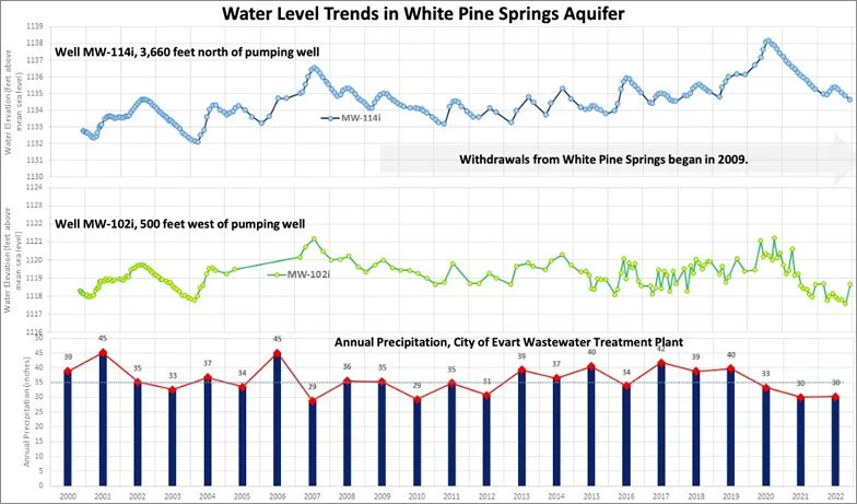
Figure 2: Groundwater Monitoring Data and Annual Precipitation (2000-2022)
Average annual precipitation, 1990-2020: 35 inches (NOAA)
RECENT MONITORING RESULTS
Groundwater levels in aquifers fluctuate several feet over the course of a year. This variation is a function of geology, as well as the amount, intensity, and timing of precipitation. Since BlueTriton’s began bottling water from the White Pine Springs well in 2009, water levels have not measurably declined in the spring aquifer, but instead remain within historic ranges.
Independent scientists and BlueTriton’s Resource Managers monitor groundwater levels for unexpected changes. Figure 2 depicts water elevations in two monitoring wells: MW-102i located 500 feet from the supply well and MW-114i located about three-quarters of a mile to the north.
FUTURE MONITORING
BlueTriton is committed to sustainable management and stewardship of natural resources. Aquifer groundwater levels, stream and lake surface levels, stream flows, and the ecological health of wetland and fish communities will continue to be monitored for the duration of BlueTriton’s operations in Osceola Township.
Aquifer water levels naturally range 1 to 2 feet from year to year, and as much as 6 feet over the entire 22-year record. Since BlueTriton began bottling water in 2009, water levels in the White Pine Springs aquifer have not measurably declined.
SUMMARY
BlueTriton manages our sources sustainably through proactive monitoring and responsible use. Water withdrawals by BlueTriton at the White Pine Springs in Osceola Township are overseen by independent scientists, and these data are shared with stakeholders. Water withdrawals from the White Pine Springs have not resulted in adverse effects to groundwater, surface water, wetlands, and other natural features in the area.
RESOURCES & INFORMATION
BlueTriton is committed to increasing the transparency of our operations and water stewardship practices through our Reading Room.
Questions about White Pine or the information contained in this summary can be directed to:
Water withdrawals from White Pine Springs are regulated locally and at the state level by:
*Footnotes:
Conserved Acres represents the total land under management by BlueTriton that is where the natural environment is protected from development and pollution through the responsible management, development, and use of natural resources.
Total Acres represents the total land under management by BlueTriton, including watersheds and wetlands.
Annual Withdrawals represent the total volume of freshwater withdrawn from spring sources during the reporting period.
Water Stress is an aggregate measure of basin physical risk which combines water scarcity, flooding, water quality and ecosystem services status. Water stress is calculated for each region using the WWF Water Risk Filter Tool.
% Annual Watershed Precipitation means the amount of water that falls on an appropriately defined amount of land (e.g., watershed) that is relevant to a specific spring source in a year.
